Philip''s Local Explorer Street Atlas Oxfordshire
Who hasn't explored and enjoyed their surrounding area in recent years and come to appreciate what is on our respective doorsteps? Philip's have created this new series for walkers, cyclists and local explorers at a scale that provides greener options to uncover all the nature and hidden gems in yo......
fra 249,-
På lager i 1 butikker
Kjøp på nett
På lager
Frakt og levering


Sammenligning av produkter
Her finner du de fire mest populære produktene i denne kategorien i en lignende prisklasse som det du ser på nå.


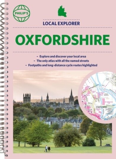
Philip''s Local Explorer Street Atlas Oxfordshire
249,-


Produktinformasjon
<p><b>Who hasn't explored and enjoyed their surrounding area in recent years and come to appreciate what is on our respective doorsteps? Philip's have created this new series for walkers, cyclists and local explorers at a scale that provides greener options to uncover all the nature and hidden gems in your local area.</b><br><br>Includes all the streets in ABINGDON-ON-THAMES, BANBURY, BICESTER, DIDCOT, HENLEY-ON-THAMES, KIDLINGTON, OXFORD, THAME, WITNEY, Adderbury, Benson, Burford, Carterton, Caversham, Chalgrove, Charlbury, Chinnor, Chipping Norton, Cholsey, Cowley, Cumnor, Eynsham, Faringdon, Goring, Grove, Headington, Highworth, Kennington, Lechlade-on-Thames, Middleton Cheney, Pangbourne, Sonning Common, Stokenchurch, Wallingford, Wantage, Wargrave, Watlington, Wheatley, Woodstock, Wootton.<br><br>The <b>detailed scale </b>allows explorers, walkers and cyclists to avoid main roads and select pathways, bridleways and lanes for optimum enjoyment. Whether it's meandering through the local parks or historic houses, exploring neighbourhood nature spots or the local town, we have the clear mapping and information you need.<br><br>If you do have to travel to reach areas you'd like to explore,<b> all A and B roads are clearly shown </b>on our Route Planner and we include <b>a large-scale city plan of Oxford</b>. Exceptional detail allows the user to pinpoint exactly where they need to go and the best route to follow.<br><br>· The <b>only atlas with every road, street and lane in the county named</b>, along with the best pedestrian routes, long-distance cycle routes.<br><br>· Highlighting lanes, alleyways, footpaths and bridleways, camping and caravan sites, golf courses, parks, gardens and many, many other places of interest<br><br>· Contains all the usual one-way streets, barriers, car parks, railway and bus stations, hospitals, colleges and schools, police and fire stations, places of worship, post offices, shopping and leisure centres</p>
Topplisten: Other Brand Bøker
Spesifikasjon
| Produkt | |
|---|---|
| Produktnavn | Philip''s Local Explorer Street Atlas Oxfordshire |
| Merke | Other Brand |
FAQ
Black Friday er fredag 27. november 2026. Sammenlign prisen på Philip''s Local Explorer Street Atlas Oxfordshire hos flere butikker, og sjekk prishistorikken der den er tilgjengelig. Kontroller at tilbudene gjelder samme modell og variant, og ta med fraktkostnaden når du sammenligner.
Populære produkter
Pris og prishistorikk
Akkurat nå er 249,- den billigste prisen for Philip''s Local Explorer Street Atlas Oxfordshire blant 1 butikker hos Prisradar. Sjekk også vår topp 5-rangering av beste bøker for å være sikker på at du gjør det beste kjøpet.
La pequena oruga glotona : Large A4 size, boardsVerhaltenssteuerung durch SachzwangeEntgeltklauseln in UnternehmenskreditverträgenNachhaltigkeit im Projektmanagement
Verhaltensprobleme bei JugendlichenLiquiditatskennziffern und VerschuldungsquoteGesundheit hinter GitternDie partiell gemeinnutzige (naturliche) Person
Internationaler Motorenkongress 2018Die Bekampfung von Rassismus und Fremdenfeindlichkeit im ArbeitsrechtErnst Cassirer und die NeurowissenschaftIgnoranzfallen am Arbeitsplatz